Tropical Storm Isaac was the 35th tropical cyclone, 20th tropical storm, that I have worked in my emergency management career. Every storm is unique but this one had a new level of uniqueness. Florida's State Emergency Response Team (still the best in the nation) had to simultaneously deal with three separate and distinct issues.
First, we were still recovering from the impacts of Tropical Storm Debby in late June. Twelve weeks ago the city of Live Oak was waist deep in fresh water from RAINFALL, and not a river. On my trips from Tallahassee along I-10 to I-75 I pass through north central Florida and am amazed at the standing water that remains in that area. A large, vacant office building at the Northwood Center on north Monroe St in Tallahassee (right next to my office) became the FEMA Joint Field Office for the disaster. Hundreds of FEMA employees arrived to work with our state Recovery people on getting help to the affected citizens and communities.
Second, there was the Republican National Convention due to begin on August 27 in Tampa. A lot of effort and planning over the last year went into preparing for this event. Considerable state, local and municipal resources were drawn from around the state to support the city of Tampa and Hillsborough County for the week of the Convention. Florida welcomes over 80 million tourists a year so the 50,000 or so convention delegates would place no strain on emergency management resources considering the 3 million plus population in the Tampa Bay area. Still, this wasn't just another industrial buyers convention. The media attention, and the information requirements that arose from this attention, was a distraction for the SERT.
Finally, there there was the uncertainty of the track and intensity of the storm itself.
I keep an eagle eye peeled during hurricane season on any actual or budding storm, but the moment the 5 day cone of error touches any part of Florida I start to resemble a Labrador staring at the ball during a game of fetch. I went into stare down mode on Wednesday morning, August 22, when the 5 A.M. National Hurricane Hurricane Center forecast for Isaac placed the southern half of the Florida Peninsula within the 5 day cone. When I awoke on Thursday morning, August 23, and looked at the 5 AM NHC forecast I put on my SERT shirt. I knew I was heading to the State Emergency Operations Center instead of my office.
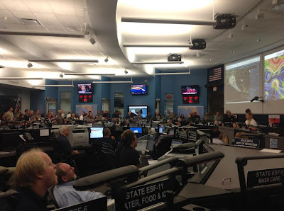
When I arrived at the EOC the Governor and his entourage were there to receive a briefing from our State Meteorologist, Amy Godsey, and the Director of the Division of Emergency Management, Bryan Koon. Mike DeLorenzo, the SERT Chief, told me that we were going to a Level 2, Partial Activation, that day. My instincts were correct. On Friday morning, August 23, the Keys and south Florida were within the 3 day cone and we were looking at a potential second hit in the Panhandle. The EOC went to a Level 1, full activation. Below is a picture of Amy Godsey briefing the SERT in the EOC on that Friday.
All day Friday we were looking at an initial strike of a Category 1 hurricane on the Keys and south Florida and then a potential Category 2 storm impacting the Panhandle. We watched the storm all day Saturday and the only question appeared to be the intensity of the storm for the 2 impacts. Correction - the only question in MY mind was the intensity for the 2 impacts. Many other inquiring minds were VERY interested in the timing of the arrival of tropical storm force winds in the Tampa Bay area on Monday.
On Sunday morning, August 26, the track of the storm shifted left to Alabama. Most of the computer models were already pointing at Louisiana but the NHC is very conservative about making radical shifts in the forecast track. When the forecast shifted left again toward Mississippi at the 11 AM forecast I suddenly had the hope that I would be able to use my tickets to the Gator football game the following Saturday.
We weren't totally out of the woods. The correct decision was made to delay the start of the RNC by one day. Amy Godsey kept her record of 40 straight storms during her tenure as the State Meteorologist without a hurricane hitting Florida. Palm Beach County received a record amount of rain from Isaac.
Yet, while I was working my rear end off over the weekend my counterparts in Louisiana and Mississippi were enjoying the end of the summer. The pressure was suddenly off us, and now is was their turn to scramble. That's the life of an emergency manager.

Thank you for another essential article. Where else could anyone get that kind of information in such a complete way of writing? These are truly enormous ideas in regarding blogging. You have touched some nice points here.
ReplyDelete