I am sure that New York City and the American Red Cross aren't resting on their laurels about how perfectly they played their response to Hurricane Sandy. Emergency management is logistics, and doing logistics in a big city is tough. After two weeks spent in NYC during the Sandy response, I feel like FEMA Administrator Craig Fugate, who recounted his response to a reporter's question about how he knew so much about emergency management by saying: "I've been doing this for so long that I've made every possible mistake and learned from it."
While in NYC I had the great opportunity to work with the Red Cross Disaster Relief Operation and the highly professional NYC Office of Emergency Management. I saw both organizations making mistakes with the exceptional clarity of one who has made the same damn mistakes myself. And some more than once.
A lot of people have years and decades of disaster experience but very few have experience in disasters dealing with millions of people. And of those who have experience in such disasters, most were operating at the street or shelter level, and not in the big emergency operations centers. I have spent most of my emergency management career working in the big EOCs, places full of so much information and so little clarity about what is really happening to those people working in the cold or the heat in the affected areas.
My job in the EOC, when boiled down to its essential essence, is to make sure the people in the street and shelter have the right kind of resource, with the right capability, in the right quantity, at the right time. This sounds simple but its not easy.
The responders in the affected area are worrying about Right Now. Right Now could be the next minute, or the next hour or Today. For them, long range planning is Tomorrow. At the State EOC in Tallahassee I can't do anything Right Now. If you need something Right Now, and that resource is already positioned in the Logistic Staging Area (LSA), I can arrange to have it delivered to you tomorrow. We can't deliver it to you Right Now because all the vehicles at the LSA are out delivering resources that were requested yesterday.
If the resource you need is not in the LSA, then I have to go get it. This means that I have to arrange for the State to buy it or request FEMA to provide it. This can take 48-96 hours, at best. And if you need it Right Now, 48-96 hours sounds like Next Year. Therefore, my time horizon is never Right Now, but is focused on what I anticipate the people in the field are going to need 48-96 hours from now.
That means that I am in the prediction business. In small disasters any errors in my predictions are usually small. In big disasters the errors in my predictions have the potential to be very large. And the question is rarely about WHAT we need but rather HOW MANY. That is why I have spent many years trying to devise ways to predict the quantity of resources that we would need in a big disaster. One of the best ways to improve predictions is to make them a collective judgment of the stakeholders involved. In Florida, we do that on the daily state mass care conference call.
What happens in big disasters is that the people in the EOCs are stuck in Right Now and aren't thinking about the next 48-96 hours. The reason they are stuck in Right Now is that they are understaffed for the size of the disaster. The reason that they are understaffed is they don't know what they don't know. You don't know what you need in a big disaster until you experience one. But big disasters don't happen that often, so few people have the experience required to deal with the more complex issues presented.
In 2009 the State of Florida ran a catastrophic hurricane exercise to test our new catastrophic hurricane plan. This was Craig Fugate's last exercise as Florida's EM Director. I was the State Mass Care Coordinator in the exercise and I was overwhelmed by the quantity and complexity of the problems that I had to address. At one point, I needed to be in 3 critical meetings at the same time. I learned that I was understaffed for the size of the disaster and needed to plan to do something about it should the real event happen.
Which brings me to forklifts and big trailers. The biggest and most impressive lesson that I learned while responding to the 8 hurricanes that hit Florida in a 16 month period during 2004 and 2005 was the critical importance of having lots of big trailers and forklifts.
In big disasters involving millions of people you need to fill the big 48 ft or 53 ft trailers and direct them to a staging area near to or within the disaster area. The staging area is important because when you order the trailer loads (48-96 hours in advance) you may not know the ultimate destination for the load.
This is the most effective way to get large quantities of "stuff" to large quantities of people in a big disaster. In the 2 weeks that I spent in NYC I didn't see or hear about people using lots of big trailers and forklifts. They were using a lot of straight trucks and unloading the cargo by hand. This technique works just fine in little disasters. In big disasters you need big trailers to push the supplies as far forward into the affected area as possible and then unload them using pre-positioned forklifts.
I spoke to several people about why they didn't use more forklifts and they said that they tried. There are thousands of forklifts in NYC but they aren't where they need them for the disaster. And moving forklifts around is H-A-R-D. They're heavy and don't travel very fast.
That is why I advised the American Red Cross to get a national forklift contract for use in big disasters such as Sandy. We used these contractors in Florida to position forklifts at over 70 Point of Distribution (POD) sites in Dade and Broward Counties after Hurricane Wilma in 2005. The contractors carried the forklifts in on flat bed trailers and dropped them off at the POD locations and field kitchen sites.
Another important reason to have the capability to quickly pre-position forklifts is that in a big disaster big trailers become a critical shortage item. In 2004 the Florida SERT and FEMA disrupted commerce in the Eastern United States because we rented every available trailer and filled them with disaster supplies. We needed the forklifts to empty the trailers at the field sites because we needed the empty trailer in order to go back and get more disaster supplies. And when you are trying to empty thousands of big trailers, you need a lot of forklifts.
Finally, to make this system work you need tractors to move the trailers to the field sites. The big "linehaul" tractors with the sleeper cabins are great to move trailers inter-city but don't serve as well positioning trailers in the city. The linehaul tractors move the freight from origin to the LSAs. The "city" tractors make the short trips from the LSA to the field site. You can contract for a fleet of city tractors with drivers and a dispatcher at the LSA to make sure the supplies get to the right place at the right time.
Boy, this all sounds expensive, you must say. But in a $30 billion or $50 billion or $100 billion disaster these costs are chump change.
Besides, there are 3 types of disaster responses: Efficient, Cheap or Quick. You have to choose one. The public and our elected officials demand that it be Quick. Our job is to make it happen.
Sunday, November 25, 2012


Wednesday, November 21, 2012
The transition to long term disaster feeding in New York City after Sandy
From November 12 to November 19 I shuttled between the New York City Emergency Operations Center (EOC) in Brooklyn, the American Red Cross Disaster Relief Operation (DRO) on 49th St. in Manhattan and my hotel near Times Square. The objective of my efforts was to achieve a coordinated transition in the City to long term disaster feeding.
.JPG) |
| The New York City Emergency Operations Center in Brooklyn |
The nationally developed Multi-Agency Feeding Plan Template describes the three phases of disaster feeding: Immediate, Sustained and Long Term. In the Immediate phase disaster feeding is conducted using local production and distribution resources. If additional resources are required, then the voluntary agencies establish a mass care feeding infrastructure consisting of field kitchens producing hot meals for distribution by Red Cross and Salvation Army vehicles. This is the Sustained Phase of disaster feeding.
As electrical power is restored to the affected homes the daily count of distributed hot meals declines and is eventually terminated. The cessation of the distribution of hot meals to the survivors is always and everywhere a political decision, made by the voluntary agencies in consultation with local elected officials. The end of the Sustained Phase of disaster feeding does not mean that the need has been eliminated. Rather, the means of delivering feeding support shifts to the Long Term Phase.
The two principle mechanisms for delivering long term disaster feeding are the Disaster Supplemental Nutrition Assistance Program (DSNAP) and the limited, targeted distribution of food boxes. At the beginning of this year I knew very little about these topics so I worked with subject matter experts from the Food and Nutrition Service of the U. S. Department of Agriculture, Feeding America and the Florida Food Bank Association to gather information.
As I produced drafts of what became the Household Disaster Feeding document my contacts sought out additional experts who also contributed to the excellent quality of the final product. We have to produce these reference documents in this bootleg manner because getting a document through the federal agency approval process is more effort than it is worth.
We finished the document in June of this year. Five months later, when I walked into the New York City EOC, I knew that the Household Disaster Feeding Template could provide a framework by which the City of New York could devise a plan for the implementation of the Long Term Phase of disaster feeding the the city.
I arrived in the NYC EOC as a Red Cross volunteer working for the Disaster Relief Operation but without an operational role in the disaster. The reason I volunteered, and the reason that I was asked by the ARC to go to the EOC, was that I had been planning to implement a catastrophic feeding plan in Florida for over 6 years. I had technical expertise appropriate to this disaster, and I also selfishly wanted to bring back any lessons learned to Florida.
.JPG) |
| The Greater New York Chapter of the American Red Cross on 49th St in Manhattan. The Sandy Disaster Relief Operation was on the 4th floor. |
In any disaster feeding operation (and Sandy was my 16th hurricane) the key events requiring the most coordination are the transitions between the phases. The disaster had already transitioned from the Immediate to the Sustained Phase. The conditions for a successful transition from the Sustained to the Long Term Phase needed to be set in place.
I had previously met with key members of the NYC emergency management team and found them to be some of the most competent and profession emergency managers that I had met in the nation. I also found the NYC emergency management team to be extremely well resourced for the difficult job of managing disasters in the city.
New York City is one of the most difficult environments I have ever encountered in which to conduct mass care. Doing anything in the city on a good day is hard. Trying to feed and shelter hundreds of thousands survivors after a disaster is a tough and complex task.
The coordination mechanism in the city for disaster feeding is called the Food Access Task Force. The concept of Food Access was new to me but it was an apt manner of describing the feeding situation in New York. In blue skies there is a food access problem in the city. A bewildering (to me) number of government and non-government programs operated to address this issue.
Two important actors in the city are City Harvest and Food Bank of New York. These non-governmental organizations provide food to a wide network of food pantries and soup kitchens. Sandy not only added survivors with food access problems to the existing population but caused damage to the capacity of the food banks and their networks.
I played a very small role during the week that I spent working with the different stakeholders on the Food Access coordination call. During the call, which was held daily, I was able to introduce the framework outlined in the Household Disaster Feeding Template. After a number of days of discussion, the concept of transitioning from the delivery of hot meals by the city and the Red Cross to a long term feeding strategy led by the food banks and the other voluntary agencies was agreed to by the participants on the call. The details of this transition and the manner in which the food banks and their networks will be resourced are still under discussion.
My flight home to Tallahassee took me through Miami. As I approached the Miami airport I looked out the window of the airplane at the tall buildings on the barrier islands in Broward and Dade counties. They brought to mind the similarly situated New York areas of Long Island, the Rockaways and Staten Island. I thought of the tremendous mass care problems presented by Sandy's surge and how Florida's State Emergency Response Team would have to deal with the same issues confronting New York City.
I also thought that when, not if, a major hurricane hits southeast Florida the mass care problems will be greater than the ones I encountered in New York City after Sandy.
My flight home to Tallahassee took me through Miami. As I approached the Miami airport I looked out the window of the airplane at the tall buildings on the barrier islands in Broward and Dade counties. They brought to mind the similarly situated New York areas of Long Island, the Rockaways and Staten Island. I thought of the tremendous mass care problems presented by Sandy's surge and how Florida's State Emergency Response Team would have to deal with the same issues confronting New York City.
I also thought that when, not if, a major hurricane hits southeast Florida the mass care problems will be greater than the ones I encountered in New York City after Sandy.
Monday, October 15, 2012
FEMA releases Mass Care Resource Typing documents for public comment
I have written before about my part time job as the Chairman of the NIMS Mass Care Working Group and our efforts to classify and define mass care resources (equipment, personnel and teams) according to the capability that they can deliver (See Creating National Standards for Mass Care Resources). Since November 2008 our Working Group has struggled to put together documentds for FEMA to approve and disseminate to the nation. This classification process is called "Resource Typing."
For reasons that I don't want to get into our Working Group has been unable to share these documents with anyone outside FEMA. Today, FEMA released the documents for public comment. (They can be found at this link, http://www.fema.gov/national-incident-management-system/national-incident-management-system-alert-01-12). With that single act, the FEMA Administrator increased mass care capability in the nation by one notch, or even two. The Mass Care Community can raise the mass care capability bar a few more notches by reading the documents and then spreading word of their existence throughout the Community.
The Resource Typing documents are an excellent source of information on mass care operations for the nation. One document types mass care equipment (like Field Kitchens) and teams (like Shelter Management Teams). Another document types Job Titles and Position Qualifications (like State Mass Care Coordinator - my personal favorite - and Shelter Manager). Additional documents are still in the hopper awaiting approval and hopefully they will be released from captivity soon.
I am very proud of our Working Group and the products that we were able to produce and deliver to the nation. These documents are now out for Public Comment. Comment on them.
For reasons that I don't want to get into our Working Group has been unable to share these documents with anyone outside FEMA. Today, FEMA released the documents for public comment. (They can be found at this link, http://www.fema.gov/national-incident-management-system/national-incident-management-system-alert-01-12). With that single act, the FEMA Administrator increased mass care capability in the nation by one notch, or even two. The Mass Care Community can raise the mass care capability bar a few more notches by reading the documents and then spreading word of their existence throughout the Community.
The Resource Typing documents are an excellent source of information on mass care operations for the nation. One document types mass care equipment (like Field Kitchens) and teams (like Shelter Management Teams). Another document types Job Titles and Position Qualifications (like State Mass Care Coordinator - my personal favorite - and Shelter Manager). Additional documents are still in the hopper awaiting approval and hopefully they will be released from captivity soon.
I am very proud of our Working Group and the products that we were able to produce and deliver to the nation. These documents are now out for Public Comment. Comment on them.
Wednesday, September 19, 2012
Dealing with TS Isaac
Tropical Storm Isaac was the 35th tropical cyclone, 20th tropical storm, that I have worked in my emergency management career. Every storm is unique but this one had a new level of uniqueness. Florida's State Emergency Response Team (still the best in the nation) had to simultaneously deal with three separate and distinct issues.
First, we were still recovering from the impacts of Tropical Storm Debby in late June. Twelve weeks ago the city of Live Oak was waist deep in fresh water from RAINFALL, and not a river. On my trips from Tallahassee along I-10 to I-75 I pass through north central Florida and am amazed at the standing water that remains in that area. A large, vacant office building at the Northwood Center on north Monroe St in Tallahassee (right next to my office) became the FEMA Joint Field Office for the disaster. Hundreds of FEMA employees arrived to work with our state Recovery people on getting help to the affected citizens and communities.
Second, there was the Republican National Convention due to begin on August 27 in Tampa. A lot of effort and planning over the last year went into preparing for this event. Considerable state, local and municipal resources were drawn from around the state to support the city of Tampa and Hillsborough County for the week of the Convention. Florida welcomes over 80 million tourists a year so the 50,000 or so convention delegates would place no strain on emergency management resources considering the 3 million plus population in the Tampa Bay area. Still, this wasn't just another industrial buyers convention. The media attention, and the information requirements that arose from this attention, was a distraction for the SERT.
Finally, there there was the uncertainty of the track and intensity of the storm itself.
I keep an eagle eye peeled during hurricane season on any actual or budding storm, but the moment the 5 day cone of error touches any part of Florida I start to resemble a Labrador staring at the ball during a game of fetch. I went into stare down mode on Wednesday morning, August 22, when the 5 A.M. National Hurricane Hurricane Center forecast for Isaac placed the southern half of the Florida Peninsula within the 5 day cone. When I awoke on Thursday morning, August 23, and looked at the 5 AM NHC forecast I put on my SERT shirt. I knew I was heading to the State Emergency Operations Center instead of my office.
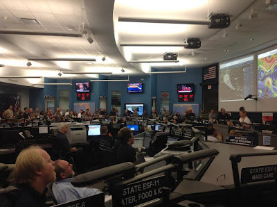
When I arrived at the EOC the Governor and his entourage were there to receive a briefing from our State Meteorologist, Amy Godsey, and the Director of the Division of Emergency Management, Bryan Koon. Mike DeLorenzo, the SERT Chief, told me that we were going to a Level 2, Partial Activation, that day. My instincts were correct. On Friday morning, August 23, the Keys and south Florida were within the 3 day cone and we were looking at a potential second hit in the Panhandle. The EOC went to a Level 1, full activation. Below is a picture of Amy Godsey briefing the SERT in the EOC on that Friday.
All day Friday we were looking at an initial strike of a Category 1 hurricane on the Keys and south Florida and then a potential Category 2 storm impacting the Panhandle. We watched the storm all day Saturday and the only question appeared to be the intensity of the storm for the 2 impacts. Correction - the only question in MY mind was the intensity for the 2 impacts. Many other inquiring minds were VERY interested in the timing of the arrival of tropical storm force winds in the Tampa Bay area on Monday.
On Sunday morning, August 26, the track of the storm shifted left to Alabama. Most of the computer models were already pointing at Louisiana but the NHC is very conservative about making radical shifts in the forecast track. When the forecast shifted left again toward Mississippi at the 11 AM forecast I suddenly had the hope that I would be able to use my tickets to the Gator football game the following Saturday.
We weren't totally out of the woods. The correct decision was made to delay the start of the RNC by one day. Amy Godsey kept her record of 40 straight storms during her tenure as the State Meteorologist without a hurricane hitting Florida. Palm Beach County received a record amount of rain from Isaac.
Yet, while I was working my rear end off over the weekend my counterparts in Louisiana and Mississippi were enjoying the end of the summer. The pressure was suddenly off us, and now is was their turn to scramble. That's the life of an emergency manager.
First, we were still recovering from the impacts of Tropical Storm Debby in late June. Twelve weeks ago the city of Live Oak was waist deep in fresh water from RAINFALL, and not a river. On my trips from Tallahassee along I-10 to I-75 I pass through north central Florida and am amazed at the standing water that remains in that area. A large, vacant office building at the Northwood Center on north Monroe St in Tallahassee (right next to my office) became the FEMA Joint Field Office for the disaster. Hundreds of FEMA employees arrived to work with our state Recovery people on getting help to the affected citizens and communities.
Second, there was the Republican National Convention due to begin on August 27 in Tampa. A lot of effort and planning over the last year went into preparing for this event. Considerable state, local and municipal resources were drawn from around the state to support the city of Tampa and Hillsborough County for the week of the Convention. Florida welcomes over 80 million tourists a year so the 50,000 or so convention delegates would place no strain on emergency management resources considering the 3 million plus population in the Tampa Bay area. Still, this wasn't just another industrial buyers convention. The media attention, and the information requirements that arose from this attention, was a distraction for the SERT.
Finally, there there was the uncertainty of the track and intensity of the storm itself.
I keep an eagle eye peeled during hurricane season on any actual or budding storm, but the moment the 5 day cone of error touches any part of Florida I start to resemble a Labrador staring at the ball during a game of fetch. I went into stare down mode on Wednesday morning, August 22, when the 5 A.M. National Hurricane Hurricane Center forecast for Isaac placed the southern half of the Florida Peninsula within the 5 day cone. When I awoke on Thursday morning, August 23, and looked at the 5 AM NHC forecast I put on my SERT shirt. I knew I was heading to the State Emergency Operations Center instead of my office.
When I arrived at the EOC the Governor and his entourage were there to receive a briefing from our State Meteorologist, Amy Godsey, and the Director of the Division of Emergency Management, Bryan Koon. Mike DeLorenzo, the SERT Chief, told me that we were going to a Level 2, Partial Activation, that day. My instincts were correct. On Friday morning, August 23, the Keys and south Florida were within the 3 day cone and we were looking at a potential second hit in the Panhandle. The EOC went to a Level 1, full activation. Below is a picture of Amy Godsey briefing the SERT in the EOC on that Friday.

All day Friday we were looking at an initial strike of a Category 1 hurricane on the Keys and south Florida and then a potential Category 2 storm impacting the Panhandle. We watched the storm all day Saturday and the only question appeared to be the intensity of the storm for the 2 impacts. Correction - the only question in MY mind was the intensity for the 2 impacts. Many other inquiring minds were VERY interested in the timing of the arrival of tropical storm force winds in the Tampa Bay area on Monday.
On Sunday morning, August 26, the track of the storm shifted left to Alabama. Most of the computer models were already pointing at Louisiana but the NHC is very conservative about making radical shifts in the forecast track. When the forecast shifted left again toward Mississippi at the 11 AM forecast I suddenly had the hope that I would be able to use my tickets to the Gator football game the following Saturday.
We weren't totally out of the woods. The correct decision was made to delay the start of the RNC by one day. Amy Godsey kept her record of 40 straight storms during her tenure as the State Meteorologist without a hurricane hitting Florida. Palm Beach County received a record amount of rain from Isaac.
Yet, while I was working my rear end off over the weekend my counterparts in Louisiana and Mississippi were enjoying the end of the summer. The pressure was suddenly off us, and now is was their turn to scramble. That's the life of an emergency manager.
Sunday, August 19, 2012
The National Mass Care Strategy
Knowledgeable sources have told me that the New National Mass Care Strategy will be unveiled to the public by the end of this month. Look for it on the National Mass Care Strategy website. I have had the opportunity to review and comment on earlier drafts and participated in July at a National Mass Care Strategy Conference with a sizable number of representatives of the national mass care community.
This is a good document and I want to commend FEMA, the American Red Cross and the National Voluntary Organizations Active in Disaster (NVOAD) for leading the effort to develop this strategy. Implementation of the strategy will begin upon publication of the document, and will take years to accomplish. I won't summarize the document here but encourage everyone involved in the mass care community to read it and think about how they can contribute to the implementation of the strategy.
I have already been thinking about where I can contribute. The Strategy has five goals:
This is a good document and I want to commend FEMA, the American Red Cross and the National Voluntary Organizations Active in Disaster (NVOAD) for leading the effort to develop this strategy. Implementation of the strategy will begin upon publication of the document, and will take years to accomplish. I won't summarize the document here but encourage everyone involved in the mass care community to read it and think about how they can contribute to the implementation of the strategy.
I have already been thinking about where I can contribute. The Strategy has five goals:
- Build Scalability into Service Delivery
- Create the Opportunity for Improved Coordination and Participation
- Engage the Whole Community
- Standardize Mass Care Practices
- Strengthen and Unify Mass Care Legal and Policy Foundations
For each Goal a number of Sub-Goals were developed. These Sub-Goals are assigned in the Strategy to one of three Implementation Teams: Planning, Operations and Legislative Action. Some of the Sub-Goals are in areas of interest to me and for which I have expertise. I will be looking to the National Mass Care Strategy website for information on when and how these Implementation Teams will be formed and for opportunities to comment on the various implementation documents as they are drafted.
In the meantime the best contribution that I can make to the Strategy is to spread the word.
Tuesday, July 17, 2012
What I learned from TS Debby
My friend Chuck Hagan, Logistics Chief for the Florida Division of Emergency Management, says that if you can still count the number of disasters you've worked, then you haven't been in the business that long. With the aid of the National Hurricane Center website, I figured out that Tropical Storm Debby was the 34th storm that I have worked. Of those 34 storms, 19 were Tropical Storms and 15 were hurricanes. I guess that means that 17 years in the disaster business isn't that long.
I learn something from every disaster and I learned a lot from Debby. What is disturbing to me is that I keep relearning the same lessons. You can't say that it's "just" a tropical storm or "just" a category 1 hurricane. This is where my experience screws me up, where I remember all those tropical storms and category 1 hurricanes that unrolled uneventfully while I sat bored in the state EOC. Every storm is unique. Every disaster is different in some important way.
Every storm is unique. Every disaster is different. We should put those phrases on a poster and post them in every EOC.
Let's go back to fundamental meteorology (I completed 2 1/2 days of meteorology classes at the Governor's Hurricane Conference in May. I guess I didn't listen well). Tropical cyclones generate four principal threats: surge, wind, tornadoes and flooding. The Saffir-Simpson Category of a storm categorizes the hazard from only one of the threats: wind. For each storm we also need to analyze the potential for damage from surge, tornadoes and flooding.
This was the rainfall forecast we received in the State EOC from the State Meteorologist on Monday afternoon, June 25th: "Locally heavy rainfall of potentially up to 6-12 inches over North Florida, 4-8 inches in Central Florida, and 3-5 inches across South Florida through the next few days will lead to flooding of some areas. Isolated storm total amounts may reach up to 25 inches in North Florida."
This was two sentences in a very complete and detailed report (Note: I am not blaming the meteorologist). The main focus, as with all tropical systems, was on the track and the potential for surge. I wasn't the only one focusing on the wrong thing. Later in the week, during a county conference call with the National Hurricane Center and the National Weather Service Offices, I heard a County Emergency Manager ask where the eye of the storm would impact the coast. The NHC forecaster correctly noted that the threat from Debby was not from the eye but from the intense rain bands many miles from the center of the storm.
The key phrase of the week, of the entire storm was: " Isolated storm total amounts may reach up to 25 inches in North Florida." Somehow, I don't remember that phrase. 25 inches of rain anywhere is going to cause problems. I started to get a clue Monday night while watching the Weather Channel, when the on-air meteorologist started talking about the "unbelievable" amounts of rain that was falling in "isolated" areas of North Florida.
Suwannee County, at the intersection of I-75 and I-10, with a County seat in Live Oak, was one of those isolated areas receiving an unbelievable amount of water. At 6 A.M. on June 26 Suwannee County, which had partially activated at 3 A.M., delivered a two sentence situation report to the State EOC: "Suwannee County is evacuating many many houses within the County as well as City of Live Oak, US Hwy 90 and Pine is waist deep... We are contacting local air boat owners and school bus persons to assist with evacuations."
That got my attention. I looked up US Hwy 90 and Pine St on the map and realized that it was in the center of the city.
Does any of this sound familiar? How about Irene, you people in the Northeast? While the World focused on the eye of Irene heading for the coast of New Jersey and downtown NYC, the enormous rain bands in advance of the storm began to drop a record breaking amount of rain on the inland states from Pennsylvania to Vermont. A NOAA forecaster at this year's National Hurricane Conference pointed out that that the ensuing rainfall amounts were accurately forecast 5 days in advance, when Irene was sitting on the Bahamas. The forecast also noted that these same areas of the mid-Atlantic and New England had already received considerable rainfall.
Yet, later in the Conference, a Vermont emergency manager described his surprise when an idyllic stream rose in fury at Irene's assault and inundated his County EOC. I shook my head at him at the time. Now I'm shaking my head at myself.
Every storm is unique. Every disaster is different.
I learn something from every disaster and I learned a lot from Debby. What is disturbing to me is that I keep relearning the same lessons. You can't say that it's "just" a tropical storm or "just" a category 1 hurricane. This is where my experience screws me up, where I remember all those tropical storms and category 1 hurricanes that unrolled uneventfully while I sat bored in the state EOC. Every storm is unique. Every disaster is different in some important way.
Every storm is unique. Every disaster is different. We should put those phrases on a poster and post them in every EOC.
Let's go back to fundamental meteorology (I completed 2 1/2 days of meteorology classes at the Governor's Hurricane Conference in May. I guess I didn't listen well). Tropical cyclones generate four principal threats: surge, wind, tornadoes and flooding. The Saffir-Simpson Category of a storm categorizes the hazard from only one of the threats: wind. For each storm we also need to analyze the potential for damage from surge, tornadoes and flooding.
This was the rainfall forecast we received in the State EOC from the State Meteorologist on Monday afternoon, June 25th: "Locally heavy rainfall of potentially up to 6-12 inches over North Florida, 4-8 inches in Central Florida, and 3-5 inches across South Florida through the next few days will lead to flooding of some areas. Isolated storm total amounts may reach up to 25 inches in North Florida."
This was two sentences in a very complete and detailed report (Note: I am not blaming the meteorologist). The main focus, as with all tropical systems, was on the track and the potential for surge. I wasn't the only one focusing on the wrong thing. Later in the week, during a county conference call with the National Hurricane Center and the National Weather Service Offices, I heard a County Emergency Manager ask where the eye of the storm would impact the coast. The NHC forecaster correctly noted that the threat from Debby was not from the eye but from the intense rain bands many miles from the center of the storm.
The key phrase of the week, of the entire storm was: " Isolated storm total amounts may reach up to 25 inches in North Florida." Somehow, I don't remember that phrase. 25 inches of rain anywhere is going to cause problems. I started to get a clue Monday night while watching the Weather Channel, when the on-air meteorologist started talking about the "unbelievable" amounts of rain that was falling in "isolated" areas of North Florida.
Suwannee County, at the intersection of I-75 and I-10, with a County seat in Live Oak, was one of those isolated areas receiving an unbelievable amount of water. At 6 A.M. on June 26 Suwannee County, which had partially activated at 3 A.M., delivered a two sentence situation report to the State EOC: "Suwannee County is evacuating many many houses within the County as well as City of Live Oak, US Hwy 90 and Pine is waist deep... We are contacting local air boat owners and school bus persons to assist with evacuations."
That got my attention. I looked up US Hwy 90 and Pine St on the map and realized that it was in the center of the city.
Does any of this sound familiar? How about Irene, you people in the Northeast? While the World focused on the eye of Irene heading for the coast of New Jersey and downtown NYC, the enormous rain bands in advance of the storm began to drop a record breaking amount of rain on the inland states from Pennsylvania to Vermont. A NOAA forecaster at this year's National Hurricane Conference pointed out that that the ensuing rainfall amounts were accurately forecast 5 days in advance, when Irene was sitting on the Bahamas. The forecast also noted that these same areas of the mid-Atlantic and New England had already received considerable rainfall.
Yet, later in the Conference, a Vermont emergency manager described his surprise when an idyllic stream rose in fury at Irene's assault and inundated his County EOC. I shook my head at him at the time. Now I'm shaking my head at myself.
Every storm is unique. Every disaster is different.
Subscribe to:
Posts (Atom)